Land Bank Partners with YSU Students, Research Shows Positive Impact of Demolitions, Revitalization
As a result of its demolition and revitalization efforts, the Mahoning County Land Bank expects to see a continuous reduction in crime rates, vacancy and blight by 2023, the next time the county is scheduled to perform property assessments. Each year, the Land Bank partners with math students at Youngstown State University to conduct research and gather data — and is already noticing a positive impact with blight remediation.
In 2018 YSU math professor Tom Wakefield and his Preparations for Industry Careers class began analyzing areas where the Land Bank has performed demolitions and/or greening projects, to assess trends and analyze their social and economic impact. The research, scheduled to continue through 2023, will provide the Land Bank and its funding sources with key information.
The partnership with YSU began with John Bralich, senior manager of GIS Services of YSU’s Department of Geography and Urban-Regional Studies, who is contracted by the Land Bank to provide data and mapping services.
“I’ve been working with the Land Bank for many years, so when Professor Wakefield approached me about finding a community partner for his classes, I knew it would be a great fit,” said Bralich.
Bralich assists the students with the mapping work and with gathering statistics for them to analyze.
“We’re all working to positively impact the community through revitalization, and all bring something different to the table,” said Bralich. “My roots are in urban studies and I’m the mapping guy. I provide all of the data for the math students and they look at the numbers and notice trends that geographers like myself wouldn’t likely see.”
Each year, the students assess different neighborhoods in Youngstown, Campbell and Struthers.
This year’s group of students found that the crime rate per capita had decreased in the targeted areas where the Land Bank performed demolition and greening work.
In 2018 they looked primarily at Lincoln Knolls on Youngstown’s East Side and areas in Campbell and Struthers. In 2019, they focused on community garden areas, including Buckeye Plat on Youngstown’s South Side, the Garden District along Mahoning Avenue on the West Side, a community garden on the East Side, and Ohio Avenue on the North Side.
This year they continued to analyze these targeted areas, as well as two additional areas on the South Side: the Cottage Grove and Taft neighborhoods.
Each year, a new group of students add data to the prior year’s findings, establishing benchmark statistics for the Land Bank’s long-term study.
“We’re looking at about one-third of the city of Youngstown,” said Bralich. “This is a long-term effort and we won’t be able to quantify the results until the next property valuation. However, one immediate impact we’re seeing is the reduction in vacancy and blight. That has improved significantly.”
Land Bank Project Coordinator Gary Davenport works directly with Bralich and the YSU students.
“This is a great opportunity to engage with community partners and give YSU students real-life experience in public data and community improvement,” Davenport said. “Thanks to the students’ statistical skills and John’s expertise with geography and urban research, we can see how effective our work has been.”
The Land Bank received funding from the Raymond John Wean Foundation for neighborhood beautification in some of the areas being analyzed. The reports will be shared with the foundation to show the results of its financial support.
“We’re thrilled to work within community partnerships,” said Davenport. “We’re all working to better our communities, and we couldn’t do it without one another.
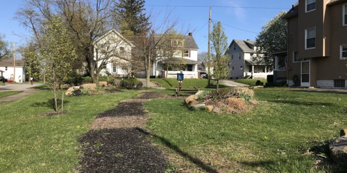
Pictured above is a post-demolition lot in the Garden District, where the Land Bank demolished a vacant home and added flower bed islands and plants before selling the property to the neighbors. It’s also one of the target areas the students examined.
